
Moderate Cycling Routes in Kent County
Cliff City Crabber Special (10.4Mi) | Hilliest Ride in Kent County (49Mi)
Just Us Kids - Family Special (41Mi) | Mid County Loop (30.9)
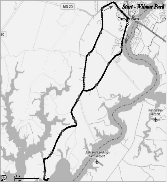
Cliff City Crabbers Special
|
Baltimore Bicycling Club |
Cliffs City Crabbers Special START=Wilmer Park, Chestertown, MD |
Rolling 21 Miles 800 Feet |
| Miles |
Turn |
Road |
∆ |
Miles |
Turn |
Road |
∆ |
|
0.0 |
L@T |
S. Cross St |
0.4 |
14.8 |
L |
Pomona Rd Store |
1.4 |
|
0.4 |
S |
Rt 289–Quaker Neck Rd |
3.6 |
16.2 |
S |
Airy Hill Rd |
2.4 |
|
4.0 |
Pomona Store on Right |
4.3 |
18.6 |
R@T |
RT20–Chestertown Rd |
0.3 |
|
|
8.3 |
BL |
Cliffs City Rd |
0.9 |
18.9 |
S |
Becomes High St |
0.5 |
|
9.2 |
! |
Road Narrows to 1 Lane |
0.2 |
19.4 |
S |
TRO High St at Circle |
0.9 |
|
9.4 |
Scenic River View |
0.0 |
20.3 |
R@TL |
S. Cross St |
0.3 |
|
|
9.4 |
UT |
U-Turn to Rt 289 |
5.4 |
20.6 |
L |
Wilmer Park |
BL=bear left BR=bearright L=left R=right S=straight SS= stop sign UT= U-Turn TRO=to remain on X= cross TL=traffic light BL=blinking light
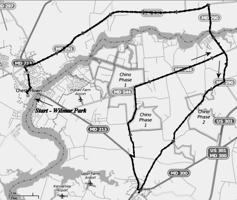
Hilliest Ride in Kent County
|
Baltimore Bicycling Club |
Hilliest Ride in Kent County START = Wilmer Park, Chestertown, MD |
Rolling with “Hills” 49 Miles 2600 Feet |
|
Miles |
Turn |
Road |
∆ |
Miles |
Turn |
Road |
∆ |
|
0.0 |
R@T |
S. Cross St |
0.3 |
28.6 |
L |
Still Pond Creek Rd |
1.6 |
|
0.3 |
L@TL |
High Street |
0.9 |
30.2 |
BR |
TRO Still Pond Creek Rd @ Bridge |
1.0 |
|
1.2 |
R |
Rt 291 – Morgnec Rd at Circle |
3.8 |
31.2 |
X@SS |
Becomes Montabello Lake Rd |
1.2 |
|
5.0 |
L |
Perkins Hill Rd |
0.8 |
32.4 |
R@T |
Smithville Rd |
0.3 |
|
5.8 |
BL |
TRO Perkins Hill |
2.1 |
32.7 |
L |
St James Rd |
2.2 |
|
7.9 |
R@T |
Rt 213 – Augustine Herman Hwy |
0.5 |
34.9 |
L@T |
St James Newtown Rd |
0.3 |
|
8.4 |
L |
Still Pond Rd |
2.8 |
35.2 |
R@T |
Rt 298 |
2.0 |
|
11.2 |
R@T |
Rt 298 – Lambs Meadow |
2.6 |
37.2 |
L |
Earl Nicholson Rd |
2.6 |
|
13.8 |
L |
Turners Creek Rd |
2.6 |
39.8 |
L@T |
Rt 20 – Chestertown Rd |
0.7 |
|
16.4 |
UT |
U-Turn at Turner Creek Wharf |
1.4 |
40.5 |
R |
Rt 446 – Broad Neck Rd |
2.3 |
|
17.8 |
R |
Bloomfield Rd |
2.5 |
42.8 |
L |
Langford Rd |
2.0 |
|
20.3 |
R@T |
Rt 566 |
1.2 |
44.8 |
L@T |
Airy Hill Rd |
2.4 |
|
21.5 |
S |
Becomes Rt 292 – Still Pond Rd |
3.5 |
47.2 |
R@T |
Rt 20 – Chestertown Rd |
2.0 |
|
25.0 |
L |
Ericsson Ave – Betterton Beach |
0.7 |
47.5 |
S |
Becomes High St |
0.4 |
|
25.7 |
R@T |
Howell Point Rd |
0.8 |
47.9 |
S |
TRO High St at Circle |
1.0 |
|
26.5 |
L |
Clark Rd |
1.6 |
48.9 |
R@TL |
S. Cross St |
0.3 |
|
28.1 |
R@SS |
Still Pond Neck Rd |
0.5 |
49.2 |
L |
Wilmar Park |
BL=bear left BR=bearright L=left R=right S=straight SS= stop sign UT= U-Turn TRO=to remain on X= cross TL=traffic light BL=blinking light

Just Us Kids - Family Special
|
Baltimore Bicycling Club |
Just Us Kids – Family Special START = Wilmer Park, Chestertown, MD |
Rolling with “Hills” 41 Miles 1600 Feet |
|
Miles |
Turn |
Road |
∆ |
Miles |
Turn |
Road |
∆ |
|
0.0 |
R@T |
S. Cross St |
0.4 |
19.6 |
L@BL |
Rt 300 – Sudlersville Rd |
0.2 |
|
0.4 |
L@TL |
Rt 213 – WashingtonAve |
0.9 |
19.8 |
QR |
Rt 213 – Church Hill Rd |
1.5 |
|
1.3 |
R@TL |
Rt 291 – Morgnec Rd |
8.5 |
21.3 |
R |
John Powell Rd |
0.2 |
|
9.8 |
R |
Rt 290 – Broad St |
1.0 |
21.5 |
L |
Ewingtown Rd |
1.4 |
|
10.8 |
S |
Chester River Bridge |
1.7 |
22.9 |
BR |
TRO Ewingtown Rd |
1.7 |
|
12.5 |
R |
Pinkney Park |
0.1 |
24.6 |
R@T |
Rt 544 – McGinnes Rd |
4.0 |
|
12.6 |
UT |
U-Turn back to Rt 290 |
0.0 |
28.6 |
L@BL |
RT 290 |
0.4 |
|
12.6 |
R |
Rt 290 – south |
0.8 |
29.0 |
R |
Crumpton Park * |
0.1 |
|
13.4 |
R |
Pondtown Rd |
4.5 |
29.1 |
UT |
U-Turn from Park |
0.0 |
|
17.9 |
X@SS |
Becomes Pinderhill Rd |
1.4 |
29.1 |
R@T |
Rt 290 north from park |
1.7 |
|
19.3 |
L@T |
Rt 19 – Main St |
0.0 |
30.8 |
L@T |
Rt 291 – Morgnec Rd |
8.5 |
|
19.3 |
X |
TRO Rt 19 @Sudlersville |
0.2 |
39.3 |
L@TL |
Rt 213 – Washington Ave |
0.9 |
|
19.5 |
R |
Parking Lot after School |
0.0 |
40.2 |
R@TL |
Cross Street |
0.5 |
|
19.5 |
L |
U-Turn from Parking |
0.1 |
40.7 |
L |
Wilmar Park |
BL=bear left BR=bearright L=left R=right S=straight SS= stop sign UT= U-Turn TRO=to remain on X= cross TL=traffic light BL=blinking light
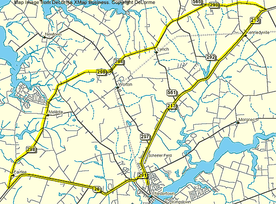
Mid County Loop
This 31-mile tour traverses the heart of Kent County. It passes through Kennedyville, Lynch, Melitota and Fairlee before returning to Chestertown on good roads.
|
Mileage
|
Direction
|
Route
|
|
0.0
|
Go north on Route 213
|
from Washington College
|
|
0.5
|
Cross
|
Rte 291
|
|
7.3
|
Pass through
|
Kennedyville
|
|
9.0
|
Turn left
|
Rte 298
|
|
10.2
|
Cross
|
Rte 448
|
|
11.5
|
Bear left on
|
Rte 298
|
|
12.9
|
Cross
|
Rte 292
|
|
14.4
|
Pass
|
Rte 561 & Lynch
|
|
16.4
|
Pass
|
Kent County High School
|
|
20.2
|
Pass
|
Melitota Store
|
|
22.9
|
Enter
|
Fairlee
|
|
24.0
|
Turn left
|
Rte 20
|
|
24.7
|
Pass
|
One-stop Store
|
|
27.7
|
Pass
|
Rte 446
|
|
29.7
|
Cross
|
Rte 514
|
|
29.9
|
Turn left
|
Rte 291
|
|
30.5
|
Turnright
|
Rte 213
|
|
30.9
|
Arrive
|
Washington College
|
Bicycling is a hazardous activity. Be cautious and always wear an approved helmet. The BBC can NOT guarantee the safety of cyclists and assumes no legal liability for injury or damage incurred. Although these routes were as accurate as possible at the time they were developed, conditions can change.
These routes were developed for the annual BBC Kent County Spring Fling event.