
Challenging Bike Routes in Kent County
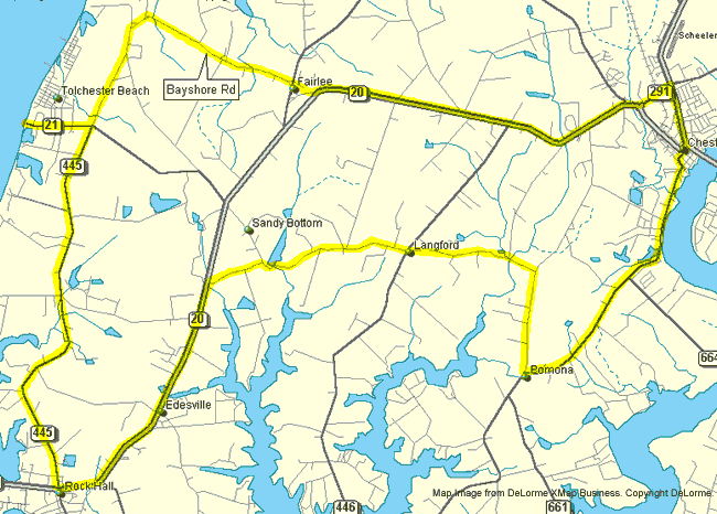
Rock Hall Ramble
This 50-mile ride is a kind of "sea to summit" tour, covering the ground between the Kent County seat and Rock Hall. It passes several fascinating sites, including Old St. Paul's, the oldest surviving Anglican Church on the Eastern Shore; and Chesapeake Farms, the DuPont Company's agricultural research center. It also offers the shops and restaurants of Rock Hall, as well as stops and facilities at Tolchester Marina at the end of Route 21 and at the store on Route 20 in Fairlee.
|
Mileage
|
Direction
|
Route
|
|
0.0
|
Go south on Rte 213
|
from Washington College
|
|
0.5
|
Turn right
|
Cross Street
|
|
2.0
|
Pass
|
CRYCC
|
|
4.8
|
Turn right at Pomona Store
|
Pomona-Lankford Rd
|
|
6.3
|
Turn right
|
Lankford-Pomona Rd
|
|
8.2
|
Cross
|
Broad Neck Rd
|
|
10.6
|
Pass
|
Old St. Paul's
|
|
10.8
|
Pass
|
Chesapeake Farms
|
|
11.5
|
Turn left
|
Route 20
|
|
15.5
|
Turn left
|
Main St. (Rte 445)
|
|
15.6
|
Turn right
|
Sharp Street
|
|
or
|
Continue south
|
Route 445
|
|
31.4
|
Cross
|
Route 20
|
|
37.2
|
Turn left
|
Route 21
|
|
38.2
|
Arrive
|
Chesapeake Bay
|
|
Return
|
Continue north on Route 445
|
|
|
39.1
|
Turn left
|
Bay Shore Road
|
|
43.3
|
Turn right
|
Route 298
|
|
Continue
|
Through Fairlee
|
|
|
43.7
|
Turn left
|
Route 20
|
|
48.7
|
Turn left
|
Route 291
|
|
49.3
|
Turn left
|
Route 213
|
|
49.7
|
Arrive
|
Washington College
|
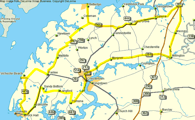
Historic County Loop
This tour is 81 miles long, so our sketch map is sketchier. Much of the route, however, is covered by other, shorter routes for which there are more detailed maps. This is a real "challenging ride," but traverses some beautiful countryside and offers several views of the Chesapeake Bay.
|
Mileage
|
Direction
|
Route
|
|
0.0
|
Go south on Rte 213
|
from Washington College
|
|
0.5
|
Turn right
|
Cross Street
|
|
2.0
|
Pass
|
CRYCC
|
|
4.8
|
Turn left at Pomona Store
|
Pomona-Lankford Rd
|
|
6.3
|
Turn left
|
Lankford-Pomona Rd
|
|
8.2
|
Cross
|
Broad Neck Rd
|
|
10.6
|
Pass
|
Old St. Paul's
|
|
10.8
|
Pass
|
Chesapeake Farms
|
|
11.5
|
Turn left
|
Route 20
|
|
15.5
|
Turn right in Rock Hall
|
Main St. (Rte 445)
|
|
21.3
|
Turn left
|
Route 21
|
|
22.3
|
Arrive
|
Chesapeake Bay
|
|
Return
|
Continue north on Route 445
|
|
|
23.2
|
Turn left
|
Bay Shore Rd
|
|
27.4
|
Turn left in Fairlee
|
Route 298
|
|
30.2
|
Pass
|
Melitota
|
|
31.6
|
Turn left
|
St. James-Newtown Rd
|
|
31.9
|
Turn right
|
St. James-Smithville Rd
|
|
34.0
|
Turn right
|
Route 297
|
|
34.3
|
Turn left
|
Montabellow Lake Rd
|
|
35.5
|
Cross
|
Cooper's Lane
|
|
36.5
|
Bear right
|
Bessick's Corner Rd
|
|
38.2
|
Turn left
|
Route 292
|
|
41.4
|
Arrive
|
Betterton
|
|
Return on 292
|
to Still Pond
|
|
|
45.4
|
Arrive
|
Still Pond
|
|
Continue
|
on Route 566
|
|
|
46.6
|
Turn left
|
Route 298
|
|
47.9
|
Cross
|
Route 448
|
|
49.2
|
Turn left
|
Route 213
|
|
51.6
|
Cross
|
Route 444
|
|
55.7
|
Pass through
|
Galena
|
|
59.6
|
Cross under
|
US Route 301
|
|
60.0
|
Turn right
|
Route 299
|
|
64.0
|
Pass through
|
Massey
|
|
67.7
|
Arrive
|
Millington
|
|
67.7
|
Turn right
|
Route 291
|
|
69.2
|
Cross over
|
US Route 301
|
|
76.6
|
Cross
|
Morgnec Road
|
|
79.1
|
Cross
|
Morgnec Creek
|
|
80.9
|
Turn left
|
Route 213
|
|
81.4
|
Arrive
|
Washington College
|
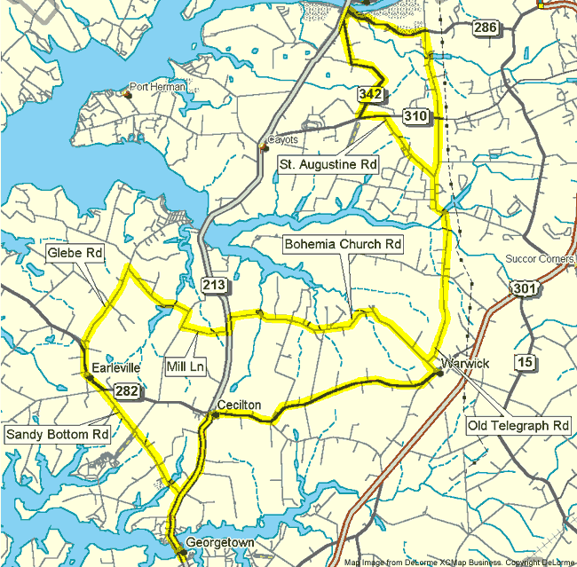
Pump House Primer
This 82-mile tour takes riders from Chestertown in Kent County to the C & D Canal in Cecil County and back again. It, too, is a "challenging ride," particularly as there is more relief in Cecil County than in Kent. In spite of this added difficulty, however, it's a wonderful tour and well worth the extra time required. The map below provides a detailed view only of the complex route the tour follows in Cecil County.
|
Mileage
|
Direction
|
Route
|
|
0.0
|
Go north on Route 213
|
From Washington College
|
|
0.2
|
Cross
|
Rte 291
|
|
1.3
|
Pass
|
Airport
|
|
2.3
|
Pass
|
Rosehill
|
|
5.4
|
Pass
|
Urieville Lake
|
|
6.6
|
Pass
|
Fair Hill Dairy
|
|
7.8
|
Arrive
|
Kennedyville
|
|
9.6
|
Pass
|
Vonnie's Restaurant
|
|
10.2
|
Pass
|
Old Shrewsbury Church
|
|
11.0
|
Cross
|
Rte 444
|
|
14.9
|
Turn left in Galena
|
Route 213
|
|
16.8
|
Cross Sassafras R.
|
Cecil County
|
|
19.9
|
Turn right in Cecilton
|
Route 282
|
|
25.2
|
Turn left in Warwick
|
Water Street
|
|
25.5
|
Bear right
|
Old Telegraph Rd.
|
|
28.6
|
Turn left at pond
|
Old Telegraph Rd
|
|
29.5
|
Continue straight
|
Old Telegraph Rd
|
|
30.7
|
Cross
|
No-name Rd
|
|
32.6
|
Turn left
|
Route 286
|
|
34.0
|
Pass
|
C&D Canal Museum
|
|
34.0
|
Pass
|
Dockside Restaurant
|
|
34.6
|
Turn left
|
George Street
|
|
34.8
|
Turn left
|
Route 342
|
|
37.6
|
Turn left
|
Route 310
|
|
38.2
|
Turn right
|
St. Augustine Rd
|
|
39.9
|
Bear right
|
Old Telegraph Rd
|
|
40.7
|
Bear right at pond
|
Old Telegraph Road
|
|
44.7
|
Bear right
|
Rumsey Road
|
|
44.9
|
Turn Right
|
Church Road
|
|
46.5
|
Turrn left
|
Bohemia Church Rd
|
|
51.5
|
Turn left
|
Route 213
|
|
51.7
|
Turn right
|
Mill Lane
|
|
52.8
|
Turn right
|
Lovers Lane
|
|
53.7
|
Pass
|
Frazer's Lake
|
|
54.9
|
Turn left
|
Glebe Road
|
|
56.7
|
Pass
|
St. Steven's Church
|
|
56.8
|
Turn left
|
Route 282
|
|
57.5
|
Pass through
|
Earleville
|
|
57.7
|
Turn right
|
Grove Neck Rd
|
|
57.7
|
Turn left immediately
|
Sandy Bottom Road
|
|
62.7
|
Turn right
|
Route 213
|
|
64.7
|
Cross
|
Sassafras River
|
|
81.5
|
Arrive
|
Washington College
|
Bicycling is a hazardous activity. Be cautious and always wear an approved helmet. The BBC can NOT guarantee the safety of cyclists and assumes no legal liability for injury or damage incurred. Although these routes were as accurate as possible at the time they were developed, conditions can change.
These routes were developed for the annual BBC Kent County Spring Fling event